 Brussels Airlines Route Map
Brussels Airlines is the flag carrier of Belgium, formed in 2006 when SN Brussels Airlines merged with Virgin Express. It joined Star Alliance in 2009 and has been wholly owned by the Lufthansa Group since 2017.
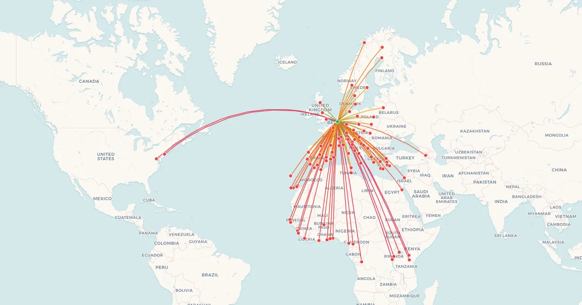
Everything it flies starts or ends in Brussels, and its network has a character of its own: next to a European network, it is one of the European airlines with the most destinations in sub-Saharan Africa, a legacy of Sabena's long-standing links with Central and West Africa.
Below is the network on a map, every route with its distance from Brussels, and the longest and shortest routes Brussels Airlines flies.
At a Glance
- Destinations
- 92
- Countries
- 43
- Hub
- BRU
- Longest route
- Brussels → Kilimanjaro6,789 km (4,218 mi)
- Shortest route
- Brussels → Paris251 km (156 mi)
BRU: Brussels Airport.
Europe (65)
| Route | Distance | Prices |
|---|---|---|
Brussels BRU → Alicante ALC Spain | 1,458 km (906 mi) | See on mapMapI've flown thisFlownCheck prices |
Brussels BRU → Athens ATH Greece | 2,101 km (1,306 mi) | See on mapMapI've flown thisFlownCheck prices |
| Brussels BRU → Barcelona BCNSpainFlights from BCN | 1,084 km (674 mi) | See on mapMapI've flown thisFlownCheck prices |
Brussels BRU → Berlin BER Germany | 643 km (400 mi) | See on mapMapI've flown thisFlownCheck prices |
| Brussels BRU → Bilbao BIOSpain | 1,013 km (629 mi) | See on mapMapI've flown thisFlownCheck prices |
Brussels BRU → Bologna BLQ Italy | 871 km (541 mi) | See on mapMapI've flown thisFlownCheck prices |
Brussels BRU → Budapest BUD Hungary | 1,139 km (708 mi) | See on mapMapI've flown thisFlownCheck prices |
| Brussels BRU → Catania CTAItaly | 1,712 km (1,064 mi) | See on mapMapI've flown thisFlownCheck prices |
| Brussels BRU → Chania CHQSeasonalGreece | 2,322 km (1,443 mi) | See on mapMapI've flown thisFlownCheck prices |
Brussels BRU → Copenhagen CPH Denmark | 754 km (469 mi) | See on mapMapI've flown thisFlownCheck prices |
| Brussels BRU → Corfu CFUSeasonal | 1,736 km (1,079 mi) | |
| Brussels BRU → Dubrovnik DBVSeasonal | 1,397 km (868 mi) | |
| Brussels BRU → Edinburgh EDI | 765 km (475 mi) | |
| Brussels BRU → Faro FAO | 1,832 km (1,138 mi) | |
| Brussels BRU → Florence FLR | 936 km (582 mi) | |
| Brussels BRU → Frankfurt FRA | 305 km (190 mi) | |
| Brussels BRU → Fuerteventura FUE | 2,931 km (1,821 mi) | |
| Brussels BRU → Funchal FNC | 2,664 km (1,655 mi) | |
| Brussels BRU → Geneva GVA | 532 km (331 mi) | |
| Brussels BRU → Göteborg GOT | 905 km (562 mi) | |
| Brussels BRU → Gran Canaria LPA | 3,051 km (1,896 mi) | |
| Brussels BRU → Hamburg HAM | 482 km (300 mi) | |
| Brussels BRU → Harstad/Narvik EVESeasonal | 2,063 km (1,282 mi) | |
| Brussels BRU → Heraklion HERSeasonal | 2,395 km (1,488 mi) | |
| Brussels BRU → Ibiza IBZSeasonal | 1,359 km (844 mi) | |
| Brussels BRU → Kemi KEMSeasonal | 2,008 km (1,248 mi) | |
| Brussels BRU → Kittilä KTTSeasonal | 2,174 km (1,351 mi) | |
| Brussels BRU → Kos KGSSeasonal | 2,380 km (1,479 mi) | |
| Brussels BRU → Kraków KRK | 1,084 km (674 mi) | |
| Brussels BRU → Lanzarote ACE | 2,871 km (1,784 mi) | |
| Brussels BRU → Lisbon LIS | 1,717 km (1,067 mi) | |
| Brussels BRU → Ljubljana LJU | 898 km (558 mi) | |
| Brussels BRU → London LHR | 350 km (217 mi) | |
| Brussels BRU → Lyon LYS | 577 km (359 mi) | |
| Brussels BRU → Madrid MAD | 1,316 km (818 mi) | |
| Brussels BRU → Málaga AGP | 1,735 km (1,078 mi) | |
| Brussels BRU → Manchester MAN | 536 km (333 mi) | |
| Brussels BRU → Marseille MRS | 832 km (517 mi) | |
| Brussels BRU → Milan LIN | 703 km (437 mi) | |
| Brussels BRU → Milan MXP | 665 km (413 mi) | |
| Brussels BRU → Munich MUC | 597 km (371 mi) | |
| Brussels BRU → Mytilene MJTSeasonal | 2,168 km (1,347 mi) | |
| Brussels BRU → Naples NAPSeasonal | 1,345 km (836 mi) | |
| Brussels BRU → Nice NCE | 831 km (516 mi) | |
| Brussels BRU → Olbia OLBSeasonal | 1,178 km (732 mi) | |
| Brussels BRU → Oslo OSL | 1,104 km (686 mi) | |
| Brussels BRU → Palma de Mallorca PMI | 1,269 km (789 mi) | |
| Brussels BRU → Paris CDG | 251 km (156 mi) | |
| Brussels BRU → Porto OPO | 1,473 km (915 mi) | |
| Brussels BRU → Prague PRG | 697 km (433 mi) | |
| Brussels BRU → Rhodes RHOSeasonal | 2,471 km (1,535 mi) | |
| Brussels BRU → Rome FCO | 1,173 km (729 mi) | |
| Brussels BRU → Samos SMISeasonal | 2,296 km (1,427 mi) | |
| Brussels BRU → Split SPUSeasonal | 1,208 km (751 mi) | |
| Brussels BRU → Stockholm ARN | 1,288 km (800 mi) | |
| Brussels BRU → Tenerife TFS | 3,095 km (1,923 mi) | |
| Brussels BRU → Toulouse TLS | 842 km (523 mi) | |
| Brussels BRU → Valencia VLC | 1,327 km (825 mi) | |
| Brussels BRU → Venice VCE | 836 km (519 mi) | |
| Brussels BRU → Vienna VIE | 925 km (575 mi) | |
| Brussels BRU → Vilnius VNO | 1,454 km (903 mi) | |
| Brussels BRU → Warsaw WAW | 1,146 km (712 mi) | |
| Brussels BRU → Zadar ZADSeasonal | 1,110 km (690 mi) | |
| Brussels BRU → Zakynthos ZTHSeasonal | 1,951 km (1,212 mi) | |
| Brussels BRU → Zurich ZRH | 483 km (300 mi) |
Middle East (1)
| Route | Distance | Prices |
|---|---|---|
Brussels BRU → Tel Aviv TLV Israel | 3,251 km (2,020 mi) | See on mapMapI've flown thisFlownCheck prices |
Asia (1)
| Route | Distance | Prices |
|---|---|---|
Brussels BRU → Yerevan EVN Armenia | 3,283 km (2,040 mi) | See on mapMapI've flown thisFlownCheck prices |
Africa (23)
| Route | Distance | Prices |
|---|---|---|
Brussels BRU → Abidjan ABJ Côte d’Ivoire | 5,135 km (3,191 mi) | See on mapMapI've flown thisFlownCheck prices |
Brussels BRU → Accra ACC Ghana | 5,055 km (3,141 mi) | See on mapMapI've flown thisFlownCheck prices |
Brussels BRU → Banjul BJL Gambia | 4,591 km (2,853 mi) | See on mapMapI've flown thisFlownCheck prices |
Brussels BRU → Bujumbura BJM Burundi | 6,476 km (4,024 mi) | See on mapMapI've flown thisFlownCheck prices |
Brussels BRU → Conakry CKY Guinea | 4,884 km (3,035 mi) | See on mapMapI've flown thisFlownCheck prices |
Brussels BRU → Cotonou COO Benin | 4,957 km (3,080 mi) | See on mapMapI've flown thisFlownCheck prices |
Brussels BRU → Dakar DSS Senegal | 4,468 km (2,776 mi) | See on mapMapI've flown thisFlownCheck prices |
Brussels BRU → Djerba DJESeasonal Tunisia | 1,961 km (1,219 mi) | See on mapMapI've flown thisFlownCheck prices |
Brussels BRU → Douala DLA Cameroon | 5,237 km (3,254 mi) | See on mapMapI've flown thisFlownCheck prices |
Brussels BRU → Entebbe EBB Uganda | 6,239 km (3,877 mi) | See on mapMapI've flown thisFlownCheck prices |
| Brussels BRU → Freetown FNA | 4,974 km (3,091 mi) | |
| Brussels BRU → Hurghada HRG | 3,611 km (2,244 mi) | |
| Brussels BRU → Kigali KGL | 6,362 km (3,953 mi) | |
| Brussels BRU → Kilimanjaro JRO | 6,789 km (4,218 mi) | |
| Brussels BRU → Kinshasa FIH | 6,236 km (3,875 mi) | |
| Brussels BRU → Lomé LFW | 4,983 km (3,096 mi) | |
| Brussels BRU → Monastir MIRSeasonal | 1,757 km (1,092 mi) | |
| Brussels BRU → Monrovia ROB | 5,154 km (3,203 mi) | |
| Brussels BRU → Nador NDRSeasonal | 1,870 km (1,162 mi) | |
| Brussels BRU → Nairobi NBO | 6,567 km (4,081 mi) | |
| Brussels BRU → Ouagadougou OUA | 4,321 km (2,685 mi) | |
| Brussels BRU → Tangier TNGSeasonal | 1,881 km (1,169 mi) | |
| Brussels BRU → Yaoundé NSI | 5,287 km (3,285 mi) |
North America and the Caribbean (2)
| Route | Distance | Prices |
|---|---|---|
Brussels BRU → New York JFK United StatesFlights from JFK | 5,886 km (3,657 mi) | See on mapMapI've flown thisFlownCheck prices |
| Brussels BRU → Washington IADSeasonalUnited States | 6,247 km (3,882 mi) | See on mapMapI've flown thisFlownCheck prices |
Network as of September 2026, compiled by My Flight Routes. Schedules change and seasonal routes come and go, so check with the airline before you book.
Related Articles
Flown Brussels Airlines? Put every flight you have taken on your own map.
Map My Flights