 JetSMART Route Map
JetSMART is an ultra low cost airline founded in Chile in 2016 that now flies as four airlines under one brand, based in Chile, Argentina, Peru and Colombia, with an all Airbus A320 family fleet.
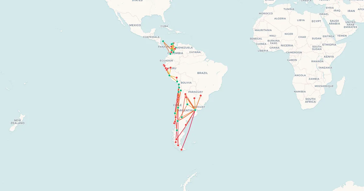
Most of its routes are domestic within each of those countries, from Arica to Punta Arenas in Chile and across Argentina from Buenos Aires Aeroparque, joined by international flights around South America.
Below is the network on two maps, domestic and international, every route with its distance, and the longest and shortest flights JetSMART operates.
At a Glance
- Destinations
- 53
- Countries
- 9
- Hubs
- SCL · AEP · LIM · BOG
- Longest route
- Santiago → Recife4,627 km (2,875 mi)
- Shortest route
- Bogotá → Pereira177 km (110 mi)
SCL: Comodoro Arturo Merino Benítez International Airport. AEP: Jorge Newbery Airpark. LIM: Jorge Chávez International Airport. BOG: El Dorado International Airport.
Domestic Routes (73)
| Route | Distance | Prices |
|---|---|---|
| Santiago SCL → Antofagasta ANF | 1,107 km (688 mi) | See on mapMapI've flown thisFlownCheck prices |
| Lima LIM → Arequipa AQP | 766 km (476 mi) | See on mapMapI've flown thisFlownCheck prices |
| Santiago SCL → Arica ARI | 1,673 km (1,040 mi) | See on mapMapI've flown thisFlownCheck prices |
| Buenos Aires AEP → Bariloche BRC | 1,335 km (830 mi) | See on mapMapI've flown thisFlownCheck prices |
| Bogotá BOG → Barranquilla BAQ | 692 km (430 mi) | See on mapMapI've flown thisFlownCheck prices |
| Bogotá BOG → Bucaramanga BGA | 290 km (180 mi) | See on mapMapI've flown thisFlownCheck prices |
| Bariloche BRC → Buenos Aires EZE | 1,309 km (813 mi) | See on mapMapI've flown thisFlownCheck prices |
| Lima LIM → Cajamarca CJA | 563 km (350 mi) | See on mapMapI've flown thisFlownCheck prices |
| Concepción CCP → Calama CJC | 1,637 km (1,017 mi) | See on mapMapI've flown thisFlownCheck prices |
| Santiago SCL → Calama CJC | 1,225 km (761 mi) | See on mapMapI've flown thisFlownCheck prices |
| San Andrés ADZ → Cali CLO | 1,164 km (723 mi) | |
| Bogotá BOG → Cali CLO | 279 km (173 mi) | |
| Bogotá BOG → Cartagena CTG | 656 km (408 mi) | |
| Cali CLO → Cartagena CTG | 773 km (480 mi) | |
| Santiago SCL → Castro MHC | 1,027 km (638 mi) | |
| Lima LIM → Chiclayo CIX | 654 km (406 mi) | |
| Antofagasta ANF → Concepción CCP | 1,503 km (934 mi) | |
| Arica ARI → Concepción CCP | 2,066 km (1,284 mi) | |
| Balmaceda BBA → Concepción CCP | 1,023 km (636 mi) | |
| Santiago SCL → Concepción CCP | 429 km (267 mi) | |
| Santiago SCL → Copiapó CPO | 682 km (424 mi) | |
| Buenos Aires AEP → Córdoba COR | 649 km (403 mi) | |
| Bariloche BRC → Córdoba COR | 1,257 km (781 mi) | |
| Bogotá BOG → Cúcuta CUC | 402 km (250 mi) | |
| Cartagena CTG → Cúcuta CUC | 432 km (268 mi) | |
| Arequipa AQP → Cusco CUZ | 314 km (195 mi) | |
| Lima LIM → Cusco CUZ | 586 km (364 mi) | |
| Buenos Aires AEP → El Calafate FTE | 2,068 km (1,285 mi) | |
| Buenos Aires EZE → El Calafate FTE | 2,038 km (1,266 mi) | |
| Arica ARI → Iquique IQQ | 244 km (152 mi) | |
| Concepción CCP → Iquique IQQ | 1,827 km (1,135 mi) | |
| Santiago SCL → Iquique IQQ | 1,431 km (889 mi) | |
| Antofagasta ANF → La Serena LSC | 724 km (450 mi) | |
| Arica ARI → La Serena LSC | 1,289 km (801 mi) | |
| Calama CJC → La Serena LSC | 856 km (532 mi) | |
| Iquique IQQ → La Serena LSC | 1,048 km (651 mi) | |
| Santiago SCL → La Serena LSC | 389 km (242 mi) | |
| San Andrés ADZ → Medellín MDE | 992 km (616 mi) | |
| Barranquilla BAQ → Medellín MDE | 530 km (329 mi) | |
| Bogotá BOG → Medellín MDE | 215 km (134 mi) | |
| Cali CLO → Medellín MDE | 310 km (193 mi) | |
| Cartagena CTG → Medellín MDE | 476 km (296 mi) | |
| Cúcuta CUC → Medellín MDE | 376 km (234 mi) | |
| Bogotá BOG → Montería MTR | 494 km (307 mi) | |
| Medellín MDE → Montería MTR | 299 km (186 mi) | |
| Buenos Aires AEP → Neuquén NQN | 995 km (618 mi) | |
| Bogotá BOG → Pereira PEI | 177 km (110 mi) | |
| Cartagena CTG → Pereira PEI | 626 km (389 mi) | |
| Lima LIM → Piura PIU | 850 km (528 mi) | |
| Buenos Aires AEP → Puerto Iguazú IGR | 1,051 km (653 mi) | |
| Buenos Aires EZE → Puerto Iguazú IGR | 1,083 km (673 mi) | |
| Santiago SCL → Puerto Montt PMC | 917 km (570 mi) | |
| Santiago SCL → Puerto Natales PNTSeasonal | 2,037 km (1,266 mi) | |
| Concepción CCP → Punta Arenas PUQ | 1,813 km (1,127 mi) | |
| Santiago SCL → Punta Arenas PUQ | 2,180 km (1,355 mi) | |
| Buenos Aires AEP → Resistencia RES | 793 km (493 mi) | |
| Buenos Aires AEP → Salta SLA | 1,276 km (793 mi) | |
| Córdoba COR → Salta SLA | 730 km (454 mi) | |
| Buenos Aires EZE → Salta SLA | 1,294 km (804 mi) | |
| Neuquén NQN → Salta SLA | 1,587 km (986 mi) | |
| Bogotá BOG → San Andrés ADZ | 1,208 km (751 mi) | |
| Bogotá BOG → Santa Marta SMR | 714 km (444 mi) | |
| Cali CLO → Santa Marta SMR | 875 km (544 mi) | |
| Medellín MDE → Santa Marta SMR | 566 km (352 mi) | |
| Lima LIM → Talara TYL | 945 km (587 mi) | |
| Lima LIM → Tarapoto TPP | 618 km (384 mi) | |
| Santiago SCL → Temuco ZCO | 638 km (396 mi) | |
| Buenos Aires AEP → Trelew REL | 1,129 km (702 mi) | |
| Lima LIM → Trujillo TRU | 490 km (304 mi) | |
| Buenos Aires AEP → Tucumán TUC | 1,070 km (665 mi) | |
| Buenos Aires EZE → Tucumán TUC | 1,086 km (675 mi) | |
| Buenos Aires AEP → Ushuaia USH | 2,381 km (1,479 mi) | |
| Buenos Aires EZE → Ushuaia USH | 2,350 km (1,460 mi) |
International Network
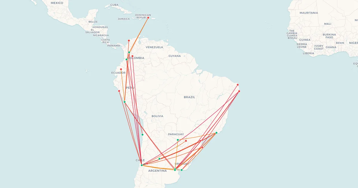
North America and the Caribbean (2)
| Route | Distance | Prices |
|---|---|---|
Cali CLO → Punta Cana PUJ Dominican Republic | 1,885 km (1,171 mi) | See on mapMapI've flown thisFlownCheck prices |
| Medellín MDE → Punta Cana PUJDominican Republic | 1,577 km (980 mi) | See on mapMapI've flown thisFlownCheck prices |
South America (32)
| Route | Distance | Prices |
|---|---|---|
Buenos Aires AEP → Asunción ASU Paraguay | 1,040 km (646 mi) | See on mapMapI've flown thisFlownCheck prices |
Santiago SCL → Bogotá BOG ColombiaFlights from BOG | 4,251 km (2,641 mi) | See on mapMapI've flown thisFlownCheck prices |
Lima LIM → Buenos Aires EZE ArgentinaFlights from EZE | 3,153 km (1,959 mi) | See on mapMapI've flown thisFlownCheck prices |
| Santiago SCL → Buenos Aires AEPArgentina | 1,147 km (713 mi) | See on mapMapI've flown thisFlownCheck prices |
| Santiago SCL → Buenos Aires EZEArgentinaFlights from EZE | 1,138 km (707 mi) | See on mapMapI've flown thisFlownCheck prices |
| Antofagasta ANF → Cali CLOColombia | 3,069 km (1,907 mi) | See on mapMapI've flown thisFlownCheck prices |
| Santiago SCL → Cali CLOColombia | 4,149 km (2,578 mi) | See on mapMapI've flown thisFlownCheck prices |
| Lima LIM → Cartagena CTGColombia | 2,504 km (1,556 mi) | See on mapMapI've flown thisFlownCheck prices |
Santiago SCL → Curitiba CWBSeasonal Brazil | 2,262 km (1,406 mi) | See on mapMapI've flown thisFlownCheck prices |
| Buenos Aires EZE → Florianópolis FLNBrazil | 1,237 km (769 mi) | See on mapMapI've flown thisFlownCheck prices |
| Santiago SCL → Florianópolis FLN | 2,217 km (1,378 mi) | |
| Santiago SCL → Foz do Iguaçu IGUSeasonal | 1,797 km (1,117 mi) | |
| Buenos Aires AEP → Lima LIM | 3,138 km (1,950 mi) | |
| Santiago SCL → Lima LIM | 2,462 km (1,530 mi) | |
| Lima LIM → Medellín MDE | 2,031 km (1,262 mi) | |
| Santiago SCL → Medellín MDE | 4,426 km (2,750 mi) | |
| Rio de Janeiro GIG → Mendoza MDZ | 2,738 km (1,701 mi) | |
| Santiago SCL → Mendoza MDZ | 196 km (122 mi) | |
| Rio de Janeiro GIG → Montevideo MVDFifth freedom | 1,824 km (1,133 mi) | |
| Santiago SCL → Montevideo MVD | 1,367 km (849 mi) | |
| Buenos Aires AEP → Natal NAT | 3,981 km (2,474 mi) | |
| Lima LIM → Quito UIO | 1,330 km (826 mi) | |
| Buenos Aires AEP → Recife REC | 3,794 km (2,357 mi) | |
| Buenos Aires EZE → Recife REC | 3,822 km (2,375 mi) | |
| Montevideo MVD → Recife RECSeasonalFifth freedom | 3,668 km (2,279 mi) | |
| Santiago SCL → Recife RECSeasonal | 4,627 km (2,875 mi) | |
| Buenos Aires AEP → Rio de Janeiro GIG | 1,969 km (1,223 mi) | |
| Asunción ASU → Rio de Janeiro GIGSeasonalFifth freedom | 1,473 km (915 mi) | |
| Córdoba COR → Rio de Janeiro GIG | 2,276 km (1,414 mi) | |
| Buenos Aires EZE → Rio de Janeiro GIG | 1,996 km (1,240 mi) | |
| Santiago SCL → Rio de Janeiro GIG | 2,934 km (1,823 mi) | |
| Santiago SCL → Trujillo TRU | 2,942 km (1,828 mi) |
Network as of September 2026, compiled by My Flight Routes. Schedules change and seasonal routes come and go, so check with the airline before you book.
Related Articles


Flown JetSMART? Put every flight you have taken on your own map.
Map My Flights